About the Red Cedar Watershed
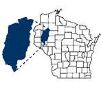
The Red Cedar River Basin drains a 1,893 square-mile area in west-central Wisconsin, and includes parts of Barron, Chippewa, Dunn, Polk, Rusk, Sawyer, St. Croix and Washburn Counties.
Part of the larger Lower Chippewa River Basin, the Red Cedar flows into the Chippewa River in southern Dunn County.
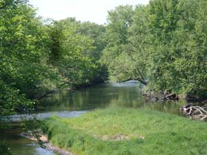
The Basin can be divided into eight smaller watersheds: Red Cedar Lake, Brill & Red Cedar Rivers, Yellow River, Lake Chetek, Pine Creek & Red Cedar Rivers, Hay River, South Fork Hay River, and Wilson Creek. These watersheds in turn are also made up of smaller streams with their own watershed boundaries. The northern parts of the basin are predominately forested. Agriculture is the dominant land use in the rest of the basin.
 Water quality problems related to phosphorus have been documented in the basin. High phosphorus levels cause algal blooms and excessive plant growth in area lakes and contribute to low oxygen levels in streams. Sources of phosphorus include agriculture, construction site erosion, streambank erosion, human and animal waste, fertilizer and organic matter. (For ideas and suggestions for what you can do to help water quality in the Red Cedar River Basin, see “Analysis and Recommendations” on the “Maps and Publications” page.)
Links between the basin’s resource base and the economic health and quality of area residents’ life are wide-ranging. Citizens, government entities and institutions depend on the area’s leading industries (agriculture, tourism, and outdoor recreation) which are, ultimately, dependent upon the health of the basin’s rivers, lakes and streams.
“A River Runs Through Us: A Water Quality Strategy for the Land and Waters of the Red Cedar River Basin” is available for download on the “Maps and Publications” page. This ten-year plan was approved by WDNR and US EPA in 2016, and it lays out the strategy for making improvements to water quality in the Red Cedar River watershed.